GA SRTM 1 second DEM
GA SRTM 1 second DEM
- Type:
Raster
- Coverage:
2014
- Produced by:
Geoscience Australia
External data
This data product is produced by an external party and is not a DEA product. DEA provides this data without modifications except where needed to make it compatible with our systems.
About
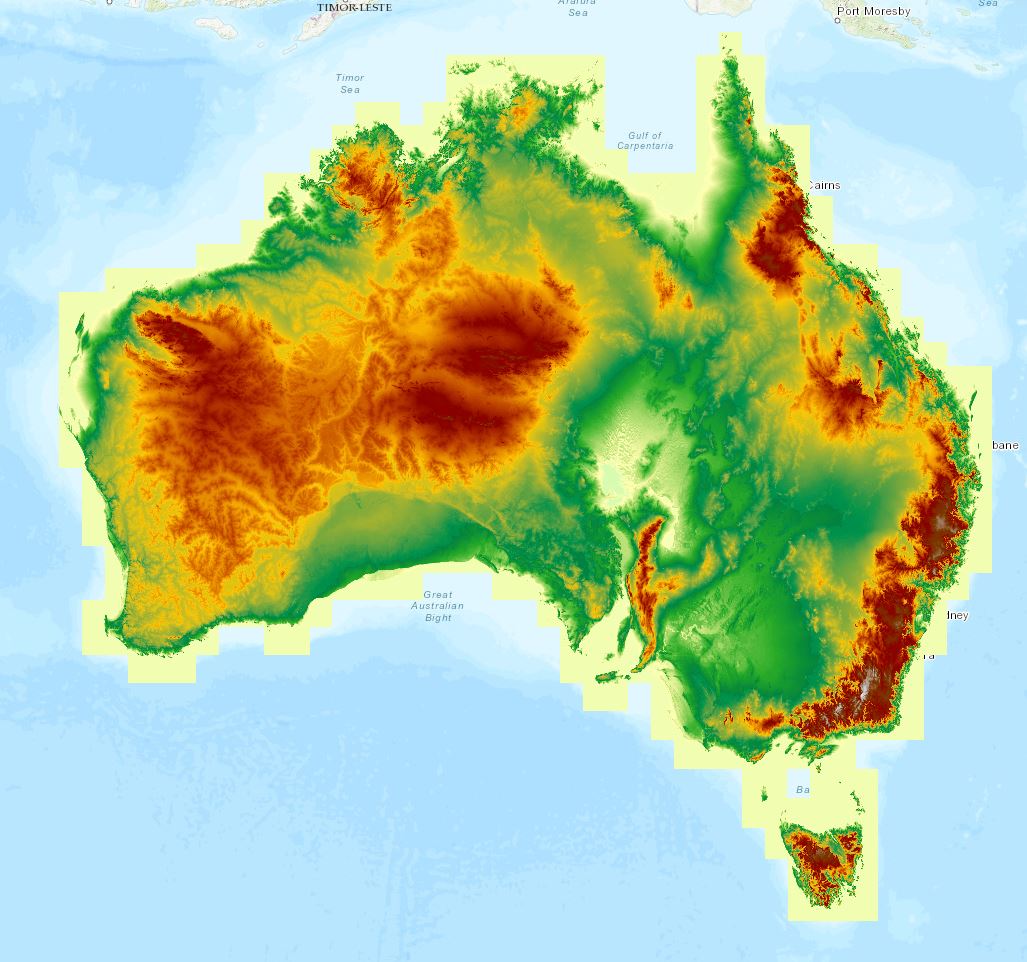
The 1 second Shuttle Radar Topography Mission (SRTM) Digital Elevation Models Version 1.0 package comprises three surface models: the Digital Elevation Model (DEM), the Smoothed Digital Elevation Model (DEM-S) and the Hydrologically Enforced Digital Elevation Model (DEM-H). The DEMs were derived from the SRTM data acquired by NASA in February 2000.
Access the data
For help accessing the data, see the Access tab.
Go to the external data page
Data Explorer
Access the data on AWS
Code examples
Key specifications
For more specifications, see the Specifications tab.
Long name |
Geoscience Australia Shuttle Radar Topography Mission 1 second DEM version 1.0 |
Bands |
|
Persistent ID |
|
Licence |
Cite this product
Data citation |
Gallant, J., Wilson, N., Dowling, T., Read, A., Inskeep, C. 2011. SRTM-derived 1 Second Digital Elevation Models Version 1.0. Record 1. Geoscience Australia, Canberra.
|
Product ID
The Product ID is ga_srtm_dem1sv1_0. This ID is used to load data from the Open Data Cube (ODC), for example dc.load(product="ga_srtm_dem1sv1_0", ...)
Bands
Bands are distinct layers of data within a product that can be loaded using the Open Data Cube (on the DEA Sandbox or NCI) or DEA’s STAC API.
Type |
Units |
Resolution |
Nodata |
Aliases |
Description |
|
|---|---|---|---|---|---|---|
dem |
float32 |
Metres |
0.00027 degrees |
See below 1 |
None |
Digital Elevation Model (DEM) |
dem_s |
float32 |
Metres |
0.00027 degrees |
See below 1 |
None |
Smoothed Digital Elevation Model (DEM-S) |
dem_h |
float32 |
Metres |
0.00027 degrees |
See below 1 |
None |
Hydrologically Enforced Digital Elevation Model (DEM-H) |
1 The ‘Nodata’ value is -340282346638528859811704183484516925440; however, ocean pixels in dem and dem_s are instead assigned a value of 0.
Product information
This metadata provides general information about the product.
Product ID |
ga_srtm_dem1sv1_0
|
Used to load data from the Open Data Cube. |
Long name |
Geoscience Australia Shuttle Radar Topography Mission 1 second DEM version 1.0 |
The full name or technical name of the product. |
Producer |
Geoscience Australia |
The external party (outside Digital Earth Australia) that produces this data. |
Spatial type |
Raster |
The most common spatial types are raster and vector. |
Temporal coverage |
2014 |
The time span for which data is available. |
Coordinate Reference System (CRS) |
The method of mapping spatial data to the Earth’s surface. |
|
Catalogue ID |
The Data and Publications catalogue (eCat) ID. |
|
Licence |
The licence and copyright. |
Product categorisation
This metadata describes how the product relates to other products.
Tags |
Access the data
Go to the external data page |
Learn more about the data from the external provider. |
|
Explore data availability |
Learn how to use the DEA Explorer |
|
Get the data online |
Learn how to access the data via AWS |
|
Code sample |
Learn how to use the DEA Sandbox |