DEA Surface Reflectance (Sentinel-2C MSI)
DEA Surface Reflectance (Sentinel-2C MSI)
- Version:
- Type:
Baseline, Raster
- Resolution:
10-60 m
- Coverage:
21 Jan 2025 to Present
- Data updates:
Daily frequency, Ongoing
About
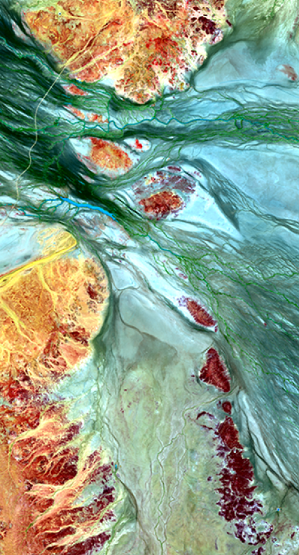
DEA Surface Reflectance Sentinel-2C Multispectral Instrument (MSI) is part of a suite of Digital Earth Australia’s (DEA) Surface Reflectance datasets that represent the vast archive of images which have been captured by the US Geological Survey (USGS) Landsat and European Space Agency (ESA) Sentinel-2 satellite programs, which have been validated, calibrated, and adjusted for Australian conditions — ready for easy analysis.
Access the data
For help accessing the data, see the Access tab.
Key specifications
For more specifications, see the Specifications tab.
Technical name |
Geoscience Australia Sentinel-2C MSI Analysis Ready Data Collection 3 |
Bands |
|
DOI |
|
Collection |
|
Licence |
Publications
Li, F., Jupp, D. L. B., Reddy, S., Lymburner, L., Mueller, N., Tan, P., & Islam, A. (2010). An evaluation of the use of atmospheric and BRDF correction to standardize Landsat data. IEEE Journal of Selected Topics in Applied Earth Observations and Remote Sensing, 3(3), 257–270. https://doi.org/10.1109/JSTARS.2010.2042281
Li, F., Jupp, D. L. B., Thankappan, M., Lymburner, L., Mueller, N., Lewis, A., & Held, A. (2012). A physics-based atmospheric and BRDF correction for Landsat data over mountainous terrain. Remote Sensing of Environment, 124, 756–770. https://doi.org/10.1016/j.rse.2012.06.018
Background
The European Space Agency (ESA) operates the Sentinel-2 series of medium-resolution satellites. These are the Sentinel-2A and Sentinel-2B satellites (since 2015) and Sentinel-2C (starting in 2025, to replace Sentinel-2A). The spectral bands and spatial resolution of Sentinel-2 are similar to those of the Landsat series, but Sentinel-2 has a higher revisit frequency and spatial coverage. A combination of Sentinel-2 and Landsat data can provide good spatial and temporal coverage of the Earth’s surface and provide useful information to monitor environmental resources over time, such as agricultural production and mining activities. However, the raw remotely sensed data received by these satellites in the solar spectral range do not directly characterise the underlying reflectance of surface objects. The data are modified by the atmosphere, variation of solar and sensor positions as well as surface anisotropic conditions. To make accurate comparisons of imagery acquired at different times, seasons and geographic locations, and detect the change of surface, it is necessary to remove/reduce these effects to ensure the data are consistent and can be compared over time.
What this product offers
This product takes Sentinel-2C imagery captured over the Australian continent and corrects for inconsistencies across land and coastal fringes. The result is accurate and standardised surface reflectance data, which is instrumental in identifying and quantifying environmental change.
The imagery is captured using the Multispectral Instrument (MSI) sensor aboard Sentinel-2C.
This product is a single, cohesive Analysis Ready Data (ARD) package, which allows the analysis of surface reflectance data as is, without the need to apply additional corrections.
It contains two sub-products that provide corrections or attribution information:
The resolution is a 10/20/60 m grid based on the ESA Level 1C archive. Note: DEA produces NBAR as part of the Landsat ARD. This product is not produced as part of the Sentinel-2 ARD.
This Collection 3 (C3) product and has been created by reprocessing Collection 1 (C1) and making improvements to the processing pipeline and packaging. See the History tab for more details.
The introduction of a maturity concept.
The Collection 3 product is comprised of data produced to varying degrees of maturity. The maturity of a dataset is dictated by the quality of the ancillary information, such as BRDF and atmospheric data, used to generate the product. The maturity levels are Near Real Time (NRT), Interim and Final. The maturity level is designated in the filename and in the metadata.
Near Real Time (NRT) is a rapid ARD product produced < 48 hours after image capture.
Interim ARD – If there are extended delays (>18 days) in delivery of inputs to the ARD model, interim production is utilised until the issue is resolved.
Final ARD - As the higher quality ancillary datasets become available, a “Final” version of the Sentinel 2 ARD data is produced, which replaces the NRT or interim product.
Applications
This product can be used for:
The development of derivative products to monitor land, inland waterways and coastal features, such as:
urban growth
coastal habitats
mining activities
agricultural activity (e.g. pastoral, irrigated cropping, rain-fed cropping)
water extent
The development of refined information products, such as:
areal units of detected surface water
areal units of deforestation
yield predictions of agricultural parcels
Compliance surveys
Emergency management
Technical information
Multispectral Instrument (MSI)
MSI is a push-broom sensor with A Three-Mirror Anastigmat (TMA) telescope with a pupil diameter equivalent to 150 mm, isostatically mounted on the platform to minimise thermo-elastic distortions. Surface Reflectance values range between 0 and 10000. MSI collects data for visible, near infrared, and short wave infrared spectral bands.
The Analysis Ready Data concept
The Analysis Ready Data (ARD) package allows you to get up and running with your analysis as quickly as possible with minimal data preparation and additional input. This makes it simpler for you to develop applications and for the database to execute queries.
The satellite data has been processed to a minimum set of requirements and organised into a form that allows immediate analysis and interoperability through time and with other datasets. It has been adapted from CEOS Analysis Ready Data (CARD4L).
The technical report containing the data summary for the Phase 1 DEA Surface Reflectance Validation is available.
ARD sub-products
The sub-product produces standardised optical surface reflectance data using robust physical models which correct for variations and inconsistencies in the image of top atmospheric reflectance values. Corrections are performed using Nadir corrected Bidirectional reflectance distribution function Adjusted Reflectance (NBAR) with an additional terrain illumination correction applied (NBART).
The NBART product depends upon the Observation Attributes (OA) product to provide accurate and reliable contextual information about the Sentinel-2C data. This ‘data provenance’ provides a chain of information which allows the data to be replicated or utilised by derivative applications. The OA takes a number of different forms, including satellite, solar and surface geometry and classification attribution labels.
Lineage
This product is derived from the ESA Sentinel-2C level 1C archive.
The Moderate Resolution Imaging Spectroradiometer (MODIS) MCD43A1 Version 6 Bidirectional Reflectance Distribution Function and Albedo (BRDF/Albedo) Model Parameters dataset was provided by the National Aeronautics and Space Administration (NASA). It was produced daily using 16 days of Terra and Aqua MODIS data at 500 m resolution. See USGS: MCD43A1, NASA: MODIS BRDF / Albedo Parameter, Schaaf et al. (2002)
The ozone data was provided by Environment Canada. See Environment Canada: Global Ozone Maps
The Aerosol Optical Thickness data was provided by the Commonwealth Scientific and Industrial Research Organisation (CSIRO). See Qin et al. (2015)
The Precipitable Water for Entire Atmosphere data was provided by the National Oceanic and Atmospheric Administration (NOAA) / Earth System Research Laboratory (ESRL) / Physical Sciences Division (PSD). See Kalnay et al. (1996)
The baseline Digital Surface Model (DSM) data produced from the Shuttle Radar Topography Mission (SRTM) was provided by the National Geospatial-Intelligence Agency (NGA). See NGA: SRTM, NASA: SRTM
Level 1C Collection 1 data was provided by the European Space agency’s Copernicus data hub, see https://scihub.copernicus.eu/
Processing steps
Software
References
Berk, A., Conforti, P., Kennett, R., Perkins, T., Hawes, F., & van den Bosch, J. (2014, June 13). MODTRAN6: A major upgrade of the MODTRAN radiative transfer code (M. Velez-Reyes & F. A. Kruse, Eds.). https://doi.org/10.1117/12.2050433
Dymond, J. R., & Shepherd, J. D. (1999). Correction of the topographic effect in remote sensing. IEEE Transactions on Geoscience and Remote Sensing, 37(5), 2618–2619. https://doi.org/10.1109/36.789656
Hudson, S. R., Warren, S. G., Brandt, R. E., Grenfell, T. C., & Six, D. (2006). Spectral bidirectional reflectance of Antarctic snow: Measurements and parameterization. Journal of Geophysical Research, 111(D18), D18106. https://doi.org/10.1029/2006JD007290
Kalnay, E., Kanamitsu, M., Kistler, R., Collins, W., Deaven, D., & Gandin, L. et al. (1996). The NCEP/NCAR 40-Year Reanalysis Project. Bulletin Of The American Meteorological Society, 77(3), 437-471. https://doi.org/10.1175/1520-0477(1996)077<0437:tnyrp>2.0.co;2
Li, F., Jupp, D. L. B., Reddy, S., Lymburner, L., Mueller, N., Tan, P., & Islam, A. (2010). An evaluation of the use of atmospheric and brdf correction to standardize landsat data. IEEE Journal of Selected Topics in Applied Earth Observations and Remote Sensing, 3(3), 257–270. https://doi.org/10.1109/JSTARS.2010.2042281
Li, F., Jupp, D. L. B., Thankappan, M., Lymburner, L., Mueller, N., Lewis, A., & Held, A. (2012). A physics-based atmospheric and BRDF correction for Landsat data over mountainous terrain. Remote Sensing of Environment, 124, 756–770. https://doi.org/10.1016/j.rse.2012.06.018
Qin, Y., Mitchell, R., & Forgan, B. W. (2015). Characterizing the aerosol and surface reflectance over Australia using AATSR. IEEE Transactions on Geoscience and Remote Sensing, 53(11), 6163–6182. https://doi.org/10.1109/TGRS.2015.2433911
Schaaf, C., Gao, F., Strahler, A., Lucht, W., Li, X., & Tsang, T. et al. (2002). First operational BRDF, albedo nadir reflectance products from MODIS. Remote Sensing Of Environment, 83(1-2), 135-148. https://www.doi.org/10.1016/s0034-4257(02)00091-3
SZA. (2011). Retrieved May 2019, from http://sacs.aeronomie.be/info/sza.php
Zhu, Z., Wang, S., & Woodcock, C. (2015). Improvement and expansion of the Fmask algorithm: cloud, cloud shadow, and snow detection for Landsats 4–7, 8, and Sentinel 2 images. Remote Sensing Of Environment, 159, 269-277. https://doi.org/10.1016/j.rse.2014.12.014
Zhu, Z., & Woodcock, C. E. (2012). Object-based cloud and cloud shadow detection in Landsat imagery. Remote Sensing of Environment, 118, 83–94. https://doi.org/10.1016/j.rse.2011.10.028
Accuracy
For detailed information on accuracy and limitations, refer to the sub-products’ pages
Quality assurance
For detailed information on quality assurance, refer to the sub-products’ pages
Product ID
The Product ID is ga_s2cm_ard_3. This ID is used to load data from the Open Data Cube (ODC), for example dc.load(product="ga_s2cm_ard_3", ...)
Bands
Bands are distinct layers of data within a product that can be loaded using the Open Data Cube (on the DEA Sandbox or NCI) or DEA’s STAC API.
Type |
Units |
Resolution |
No-data |
Aliases |
Description |
|
|---|---|---|---|---|---|---|
nbart_coastal_aerosol |
int16 |
- |
60 |
-999 |
nbart_band01
coastal_aerosol
|
NBART surface reflectance useful for shallow water and fine atmospheric particles like dust and smoke. Equivalent wavelength: 444.2 nm; Bandwidth: 21 nm. |
nbart_blue |
int16 |
- |
10 |
-999 |
nbart_band02
blue
|
NBART surface reflectance for the blue spectral band. Equivalent wavelength: 489.0 nm; Bandwidth: 65 nm. |
nbart_green |
int16 |
- |
10 |
-999 |
nbart_band03
green
|
NBART surface reflectance for the green spectral band. Equivalent wavelength: 560.6 nm; Bandwidth: 36 nm. |
nbart_red |
int16 |
- |
10 |
-999 |
nbart_band04
red
|
NBART surface reflectance for the red spectral band. Equivalent wavelength: 666.5 nm; Bandwidth: 30 nm. |
nbart_red_edge_1 |
int16 |
- |
20 |
-999 |
nbart_band05
red_edge_1
|
NBART surface reflectance of the near-infrared (NIR) range useful for detecting vegetation. Equivalent wavelength: 707.1 nm; Bandwidth: 15 nm. |
nbart_red_edge_2 |
int16 |
- |
20 |
-999 |
nbart_band06
red_edge_2
|
NBART surface reflectance of the near-infrared range (NIR) useful for detecting vegetation. Equivalent wavelength: 741.1 nm; Bandwidth: 15 nm. |
nbart_red_edge_3 |
int16 |
- |
20 |
-999 |
nbart_band07
red_edge_3
|
NBART surface reflectance of the near-infrared (NIR) range useful for detecting vegetation. Equivalent wavelength: 784.7 nm; Bandwidth: 21 nm. |
nbart_nir_1 |
int16 |
- |
10 |
-999 |
nbart_band08
nir_1
nbart_common_nir
|
NBART surface reflectance of the near-infrared (NIR) range. Equivalent wavelength: 834.6 nm; Bandwidth: 114 nm. |
nbart_nir_2 |
int16 |
- |
20 |
-999 |
nbart_band8a
nir_2
|
NBART surface reflectance of the near-infrared (NIR) range which is narrower than ‘nbart_nir_1’. Equivalent wavelength: 865.6 nm; Bandwidth: 20 nm. |
nbart_swir_2 |
int16 |
- |
20 |
-999 |
nbart_band11
swir_2
nbart_common_swir_1
swir2
|
NBART surface reflectance of the short-wave infrared (SWIR-2) range. Equivalent wavelength: 1612.0 nm; Bandwidth: 89 nm. |
nbart_swir_3 |
int16 |
- |
20 |
-999 |
nbart_band12
swir_3
nbart_common_swir_2
|
NBART surface reflectance of the short-wave infrared (SWIR-3) range. Equivalent wavelength: 2191.3 nm; Bandwidth: 182 nm. |
oa_s2cloudless_mask |
uint8 |
Classification |
60 |
0 |
s2cloudless_mask
|
The s2cloudless cloud mask band identifies the presence of clouds. Classification values: |
oa_s2cloudless_prob |
float64 |
- |
60 |
NaN |
s2cloudless_prob
|
The s2cloudless cloud probabilities band provides the probabilities of cloud presence as values between 0.0 and 1.0. |
oa_fmask |
uint8 |
Classification |
20 |
0 |
fmask
|
Fmask: A categorical classification layer produced using the automated Fmask (‘Function of mask’) algorithm, used to mask out unwanted observations in satellite imagery (e.g. cloud or shadow). Classification values: |
oa_nbart_contiguity |
uint8 |
Classification |
10 |
255 |
nbart_contiguity
|
NBART contiguity: A layer indicating whether each pixel is ‘spectrally contiguous’, meaning that it contains valid observations in every spectral band. Classification values: |
oa_azimuthal_exiting |
float32 |
Degrees |
20 |
NaN |
azimuthal_exiting
|
Azimuthal exiting: The angle between true north and the exiting direction in the slope geometry. |
oa_azimuthal_incident |
float32 |
Degrees |
20 |
NaN |
azimuthal_incident
|
Azimuthal incident: The angle between true north and the incident direction in the slope geometry. |
oa_combined_terrain_shadow |
uint8 |
Classification |
20 |
255 |
combined_terrain_shadow
|
Combined terrain shadow: Terrain shadow. Classification values: |
oa_exiting_angle |
float32 |
Degrees |
20 |
NaN |
exiting_angle
|
Exiting angle: The angle between a ray reflected from a surface and the line perpendicular to the surface at the point of emergence. |
oa_incident_angle |
float32 |
Degrees |
20 |
NaN |
incident_angle
|
Incident angle: The angle between a ray incident on a surface and the line perpendicular to the surface at the point of incidence. |
oa_relative_azimuth |
float32 |
Degrees |
20 |
NaN |
relative_azimuth
|
Relative azimuth: The relative azimuth angle between the sun and view directions. |
oa_relative_slope |
float32 |
Degrees |
20 |
NaN |
relative_slope
|
Relative slope: The relative azimuth angle between the incident and exiting directions in the slope geometry. |
oa_satellite_azimuth |
float32 |
Degrees |
20 |
NaN |
satellite_azimuth
|
Satellite azimuth: The angle of the satellite’s position from true north; i.e. the angle between true north and a vertical circle passing through the satellite and the point being imaged on Earth. |
oa_satellite_view |
float32 |
Degrees |
20 |
NaN |
satellite_view
|
Satellite view or satellite zenith: The angle between the zenith and the satellite. (The zenith is the point in the sky or celestial sphere directly above the point being imaged on Earth.) |
oa_solar_azimuth |
float32 |
Degrees |
20 |
NaN |
solar_azimuth
|
Solar azimuth: The angle of the sun’s position from true north; i.e. the angle between true north and a vertical circle passing through the sun and the point being imaged on Earth. |
oa_solar_zenith |
float32 |
Degrees |
20 |
NaN |
solar_zenith
|
Solar zenith: The angle between the zenith and the centre of the sun’s disc. |
oa_time_delta |
float32 |
Seconds |
20 |
NaN |
time_delta
|
Timedelta: The time from satellite apogee (the point of orbit at which the satellite is furthest from the Earth). |
For all ‘nbart_’ bands, Surface Reflectance is scaled between 0 and 10,000.
Product information
This metadata provides general information about the product.
Product ID |
ga_s2cm_ard_3
|
Used to load data from the Open Data Cube. |
Short name |
DEA Surface Reflectance (Sentinel-2C MSI) |
The name that is commonly used to refer to the product. |
Technical name |
Geoscience Australia Sentinel-2C MSI Analysis Ready Data Collection 3 |
The full technical name that refers to the product and its specific provider, sensors, and collection. |
Version |
3.2.1 |
The version number of the product. See the History tab. |
Lineage type |
Baseline |
Baseline products are produced directly from satellite data. |
Spatial type |
Raster |
Raster data consists of a grid of pixels. |
Spatial resolution |
10-60 m |
The size of the pixels in the raster. |
Temporal coverage |
21 Jan 2025 to Present |
The time span for which data is available. |
Update frequency |
Daily |
The expected frequency of data updates. Also called ‘Temporal resolution’. |
Update activity |
Ongoing |
The activity status of data updates. |
DOI |
The Digital Object Identifier. |
|
Catalogue ID |
The Data and Publications catalogue (eCat) ID. |
|
Licence |
See the Credits tab. |
Product categorisation
This metadata describes how the product relates to other products.
Collection |
|
Tags |
geoscience_australia_sentinel_2_collection_3, analysis_ready_data, satellite_images, earth_observation, sentinel, european |
Access the data
DEA Explorer |
Learn how to use the DEA Explorer. |
|
Data sources |
Learn how to access the data via AWS. |
|
Code examples |
Learn how to use the DEA Sandbox. |
|
Web services |
Learn how to use DEA’s web services. |
How to access Sentinel-2 data using the Open Data Cube
This product is contained in the Open Data Cube instance managed by Digital Earth Australia (DEA). This simplified process allows you to query data from its sub-products as part of a single query submitted to the database.
Introduction to DEA Surface Reflectance (Sentinel-2, Collection 3)
How to access DEA Maps
To view and access the data interactively via a web map interface:
Visit DEA Maps
Click Explore map data
Select Baseline satellite data > DEA Surface Reflectance (Sentinel-2)
Click Add to the map
Version history
Versions are numbered using the Semantic Versioning scheme (Major.Minor.Patch). Note that this list may include name changes and predecessor products.
v3.2.1 |
- |
Current version |
v1.0.0 |
of |
Acknowledgments
This research was undertaken with the assistance of resources from the National Computational Infrastructure (NCI), which is supported by the Australian Government.
Contains modified Copernicus Sentinel data 2015-present.
The authors would like to thank the following organisations:
National Aeronautics and Space Administration (NASA)
Environment Canada
The Commonwealth Scientific and Industrial Research Organisation (CSIRO)
National Oceanic and Atmospheric Administration (NOAA) / Earth System Research Laboratories (ESRL) / Physical Sciences Laboratory (PSD)
The National Geospatial-Intelligence Agency (NGA)
The United States Geological Survey (USGS) / Earth Resources Observation and Science (EROS) Center
Spectral Sciences Inc.
License and copyright
© Commonwealth of Australia (Geoscience Australia).
Released under Creative Commons Attribution 4.0 International Licence.