DEA Tidal Composites
DEA Tidal Composites
ga_s2_tidal_composites_cyear_3
- Version:
- Type:
Derivative, Raster
- Resolution:
10 m
- Coverage:
2016 to 2024
- Data updates:
Yearly frequency, Ongoing
About
Digital Earth Australia (DEA) Tidal Composites are cloud-free imagery mosaics of Australia’s coasts, estuaries and reefs at low and high tide. Calculated using a geometric median of Sentinel-2 imagery from the highest and lowest 15% of observed tides, DEA Tidal Composites deliver an annually updated snapshot of high and low tide Australian coastal environments.
Streaming data from AWS is strongly recommended
DEA Tidal Composite data is extremely large with files up to 15 GB in size. We strongly recommend streaming data directly from the cloud rather than downloading the data. Please see the instructions on the Access tab: How to stream data from AWS
Access the data
For help accessing the data, see the Access tab.
Key specifications
For more specifications, see the Specifications tab.
Technical name |
Geoscience Australia Sentinel-2 Tidal Composites Calendar Year Collection 3 |
Bands |
|
DOI |
|
Currency |
|
Parent products |
Sentinel-2A Analysis Ready Data, Sentinel-2B Analysis Ready Data, Sentinel-2C Analysis Ready Data |
Collection |
|
Licence |
Cite this product
Data citation |
Newey, V., Bishop-Taylor, R., Phillips, C., Sagar, S. (2025). Digital Earth Australia Tidal Composites. Geoscience Australia, Canberra. https://doi.org/10.26186/150381
|
Paper citation |
Sagar, S., Phillips, C., Bala, B., Roberts, D., Lymburner, L., 2018. Generating continental scale pixel-based surface reflectance composites in coastal regions with the use of a multi-resolution tidal model. Remote Sensing. 10, 480. https://doi.org/10.3390/rs10030480
|
Publications
Sagar, S., Phillips, C., Bala, B., Roberts, D., & Lymburner, L. (2018). Generating Continental Scale Pixel-Based Surface Reflectance Composites in Coastal Regions with the Use of a Multi-Resolution Tidal Model. Remote Sensing, 10, 480. https://doi.org/10.3390/rs10030480
Background
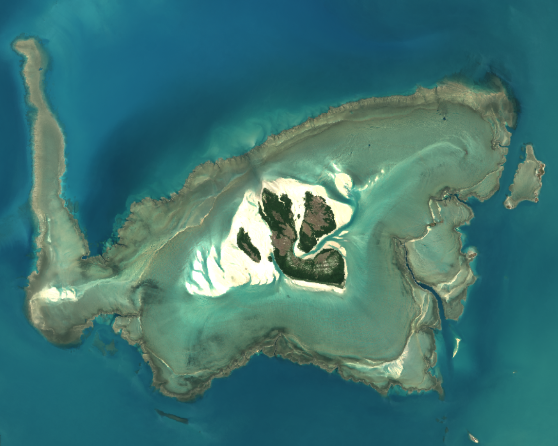
Intertidal zones are coastal environments that are exposed to both air and water at different times due to the cycle of low and high tides. These zones can include sandy beaches, tidal flats, rocky shores, and reefs. Many of them are critical coastal habitats and ecosystems which support a wide range of species and ecosystem services. Increasingly, these dynamic environments are faced with threats such as land reclamation, coastal erosion, and rising sea levels.
The ever-changing nature of the tides makes it difficult to systematically capture consistent imagery of coastal environments, particularly across large regions and in remote areas of the country. This is where Geomedian statistical techniques can be used. These are robust techniques which combine tide-attributed time-series satellite imagery to produce representative and artefact-free imagery ‘composites’ of Australia’s coastal high and low tide environments.
What this product offers
The DEA Tidal Composites product provides cloud-free satellite imagery composites capturing the Australian coastal zone at high and low tide. By applying a geometric median (geomedian) calculation to the highest and lowest 15% of satellite-observed tidal conditions, multiple satellite images from the Digital Earth Australia (DEA) Sentinel-2 analysis-ready data (ARD) archive are combined into high quality annual imagery composites.
Input satellite images are tidally filtered using pixel-based tide modelling generated from a locally optimised ensemble of top-performing global tide models (see below). This ensemble approach was implemented to account for the varying performance and biases of individual ocean models across Australia’s complex coastal regimes.
Because the geomedian calculation maintains the spectral relationships between satellite bands (Roberts et al., 2017), the composites deliver robust and valid surface reflectance spectra. This provides clean, cloud-free imagery covering the shallow water and intertidal regions of Australia (Sagar et al., 2018), suitable for downstream applications such as habitat mapping and Machine Learning (ML) classification (Li et al., 2012) .
Alongside low and high tide imagery, the product includes associated quality assurance layers that detail the specific tide-height thresholds used to filter the pixels during the compositing process, as well as a count of the clear satellite observations that contributed to each pixel.
Applications
Here are some of the ways this data product can be used:
Mapping coastal environments and cover types usually hidden beneath the ocean’s surface at high tide.
Monitoring for change across Australia’s dynamic coastal environments.
Visualising how ocean tides influence Australia’s coastal environments.
Training machine learning models and classifiers that require high quality coastal imagery.
Technical information
Features
This product consists of 25 continental (coastal) coverage data layers, including 11 geomedian surface reflectance layers for high and low tide respectively (consistent with DEA’s Sentinel-2 ARD), and three quality assurance pixel-level metadata layers. Datasets are provided as continental 10 m resolution GeoTIFFs covering the entire Australian coastal zone.
All datasets are produced annually from a 3-year composite of DEA Sentinel-2 Collection 3 surface reflectance data. The product time series commences from 2016, with datasets labelled by the middle year of data. For example, the 2017 layer combines data from 2016, 2017, and 2018. Updates to the product suite are scheduled annually. DEA Tidal Composites is spatially and temporally aligned to the resolution and timesteps of the DEA Intertidal product suite.
Datasets
Annual raster files for each of the product bands are available in DEA’s Amazon S3 bucket as continental mosaics in cloud-optimised GeoTIFF (COG) format. These files support fast and efficient data streaming.
For access and usage information, see the Access tab.
DEA Tidal Composites data follows the DEA Collection 3 naming conventions:
ga_s2_tidal_composites_cyear_3_mosaic_2024--P1Y_low-red.tif
{Organisation}_{Platform}_{Product}_{Reporting period}_{Collection}_{Region}_{Data date}--{Data period}_{Band name}.{File extension}
Multi-band annual continental data Virtual Raster (VRT) mosaics are also provided for fast and efficient streaming of true colour (red/green/blue) and false colour (green/SWIR/NIR) imagery composites in a GIS environment (e.g. QGIS, Esri ArcGIS Pro). These VRT files combine and stream multiple single-band COG datasets via a single layer. Here’s an example of the VRT file naming convention:
ga_s2_tidal_composites_cyear_3_mosaic_2024--P1Y_vrt-low-truecolour.vrt
Product layers
See the attributes of these layers in the Specifications tab.
Low tide composites (multiple ‘low_’ bands)
The 11 bands prefixed with low_ are provided at 10 m spatial resolution (matching Sentinel-2). Each band represents an annual imagery composite generated by combining the lowest 15% of satellite-observed tidal conditions over a 3-year analysis epoch using a geomedian calculation. Because the geomedian process preserves spectral relationships, these bands deliver robust data for downstream analysis of coastal environments at low tide.
High tide composites (multiple ‘high_’ bands)
The 11 bands prefixed with high_ are provided at 10 m spatial resolution (matching Sentinel-2). Each band represents an annual imagery composite generated by combining the highest 15% of satellite-observed tidal conditions over a 3-year analysis epoch using a geomedian calculation. Because the geomedian process preserves spectral relationships, these bands deliver robust data for downstream analysis of coastal environments at high tide.
Quality assurance: Low threshold (qa_low_threshold)
This quality assurance layer records the maximum tide height included in the low tide composites. While this typically represents the 15th percentile of satellite-observed tides, pixels lacking 20 clear observations within this range are gap-filled with the next lowest available observations. When gap-filling occurs, the layer reports the highest tide height included to reach the 20-observation minimum. While this layer extends inland for modelling purposes, tide heights are only valid for marine and coastal pixels.
Quality assurance: High threshold (qa_high_threshold)
This quality assurance layer records the minimum tide height included in the high tide composites. While this typically represents the 85th percentile of satellite-observed tides, pixels lacking 20 clear observations within this range are gap-filled with the next highest available observations. When gap-filling occurs, the layer reports the lowest tide height included to reach the 20-observation minimum. While this layer extends inland for modelling purposes, tide heights are only valid for marine and coastal pixels.
Quality assurance: Count clear (qa_count_clear)
This pixel-based quality assurance layer represents the number of clear observations per pixel that are used in both the high and low tide composites. This layer typically represents 15% of the total count of all clear satellite observations. When this value would be less than 20, the nearest tide-height observations (if available) are used to gapfill up to a count of 20 clear observations.
Ensemble tide modelling
The Ensemble Tidal Modelling approach was implemented to account for the varying performance and biases of existing global ocean tide models across the complex tidal regimes and coastal regions of Australia. The ensemble process utilises ancillary data to select and weight tidal models at any given coastal location based on how well each model correlates with local satellite-observed patterns of tidal inundation and water levels measured by satellite altimetry. A single ensemble tidal output was generated by combining the top three locally optimal models, and used for all downstream product workflows.
Ensemble tide modelling was implemented in the eo-tides Python package which integrates satellite Earth observation data with tide modelling (Bishop-Taylor et al. 2025). It leverages tide modelling functionality from the pyTMD package. The ensemble was based on 9 commonly-used global ocean tidal models:
Empirical Ocean Tide Model (EOT20; Hart-Davis et al., 2021)
Finite Element Solution tide models (FES2012, FES2014, FES2022; Carrère et al., 2012; Lyard et al., 2021; Carrère et al., 2022)
TOPEX/POSEIDON global tide models (TPXO8, TPXO9, TPXO10; Egbert and Erofeeva., 2002, 2010)
Global Ocean Tide models (GOT4.10, GOT5.6; Ray, 2013, Padman et al., 2018)
Lineage
The DEA Tidal Composites product suite extends the concepts developed in the High and Low Tide Composites (HLTC) product (Sagar et al. 2018), using higher resolution 10 m Sentinel-2 data in place of the original 30 m Landsat data and improved tide modelling techniques to improve high and low tide representation.
Processing steps
1. Load and pre-process data
Load analysis ready satellite data from Sentinel-2A, -2B, and -2C for the epoch of interest.
Remove sunglinted pixels by masking out pixels with glint angles of less than 20 degrees.
Proceed with tide modelling and geomedian calculation only if the full time-series of input satellite images has 50 or more observations.
2. Calculate high and low tide geomedian composites
Model tide heights for the spatial extent and timesteps of the loaded satellite data array using the ensemble tide modelling approach.
Attribute tide heights to the valid satellite observations.
Rank all observations by ascending tide height.
Select the observations in the top and bottom 15% of satellite-observed tide heights by calculating their associated tide height rankings.
If the number of observations in the top and bottom 15% is less than 20, gapfill up to the count of 20 observations by taking the next highest or lowest tide heights from the full stack of satellite observations respectively.
Calculate a geomedian on each tidally-filtered subset and count the contributing number of clear observations.
Software
This work was enabled by a range of Python libraries and packages whose code repositories include:
DEA Intertidal — DEA Intertidal product generation workflows.
eo-tides — Tools for integrating satellite Earth observations with tide modelling.
DEA Tools — Earth observation data manipulation tools.
PyTMD — Python-based tidal prediction software.
odc-algo — Algorithms for use with Open Data Cube workflows.
References
Bishop-Taylor, R., Phillips, C., Sagar, S., Newey, V., & Sutterley, T., 2025. eo-tides: Tide modelling tools for large-scale satellite Earth observation analysis. Journal of Open Source Software, 10(109), 7786. https://doi.org/10.21105/joss.07786
Carrère L., F. Lyard, M. Cancet, A. Guillot, L. Roblou, 2012. FES2012: A new global tidal model taking advantage of nearly 20 years of altimetry, Proceedings of meeting “20 Years of Altimetry”, Venice 2012
Carrère L., F. Lyard, M. Cancet, D. Allain, M. Dabat, E. Fouchet, E. Sahuc, Y. Faugere, G. Dibarboure, N. Picot, 2022. A new barotropic tide model for global ocean: FES2022, 2022 Ocean Surface Topography Science Team Meeting”, Venice 2022
Egbert, G. D., & Erofeeva, S. Y. (2002). Efficient Inverse Modeling of Barotropic Ocean Tides. Journal of Atmospheric and Oceanic Technology, 19(2), 183–204. https://doi.org/10.1175/1520-0426(2002)019<0183:EIMOBO>2.0.CO;2
Egbert, G.D., Erofeeva, S.Y., 2010. The OSU TOPEX/Poseiden Global Inverse Solution TPXO [WWW Document]. TPXO8-Atlas Version 10. URL http://volkov.oce.orst.edu/tides/global.html (accessed 2.15.16).
Hart-Davis, M.G., Piccioni, G., Dettmering, D., Schwatke, C., Passaro, M., Seitz, F., 2021. EOT20: a global ocean tide model from multi-mission satellite altimetry. Earth System Science Data 13, 3869–3884.
Li, F., Jupp, D. L. B., Thankappan, M., Lymburner, L., Mueller, N., Lewis, A., & Held, A. (2012). A physics-based atmospheric and BRDF correction for Landsat data over mountainous terrain. Remote Sensing of Environment, 124, 756–770. https://doi.org/10.1016/j.rse.2012.06.018
Lyard, F.H., Allain, D.J., Cancet, M., Carrère, L., Picot, N., 2021. FES2014 global ocean tide atlas: design and performance. Ocean Science 17, 615–649.
Padman, L., Siegfried, M.R., Fricker, H.A., 2018. Ocean Tide Influences on the Antarctic and Greenland Ice Sheets, Reviews of Geophysics, 56, 142-184.
Ray, R. D., 2013. Precise comparisons of bottom-pressure and altimetric ocean tides. Journal of Geophysical Research: Oceans, 118(9), 4570–4584.
Roberts, D., Mueller, N., & Mcintyre, A. (2017). High-Dimensional Pixel Composites From Earth Observation Time Series. IEEE Transactions on Geoscience and Remote Sensing, 55(11), 6254–6264. https://doi.org/10.1109/TGRS.2017.2723896
Rubel, F., & Kottek, M. (2010). Observed and projected climate shifts 1901-2100 depicted by world maps of the Köppen-Geiger climate classification. Meteorologische Zeitschrift, 19, 135–141. https://doi.org/10.1127/0941-2948/2010/0430
Sagar, S., Phillips, C., Bala, B., Roberts, D., & Lymburner, L. (2018). Generating Continental Scale Pixel-Based Surface Reflectance Composites in Coastal Regions with the Use of a Multi-Resolution Tidal Model. Remote Sensing, 10, 480. https://doi.org/10.3390/rs10030480
Sagar, S., Roberts, D., Bala, B., & Lymburner, L. (2017). Extracting the intertidal extent and topography of the Australian coastline from a 28year time series of Landsat observations. Remote Sensing of Environment, 195, 153–169. https://doi.org/10.1016/j.rse.2017.04.009
Limitations
Natural biases exist in the imaging of coastal tide ranges by orbiting spectral satellites such as Sentinel-2. Attempts to quantify these offsets are reported in the supporting DEA Intertidal Tide Attribute layers. These biases mean that while DEA Tidal Composites represent the upper and lower 15 % of all satellite observations of the local tide range, they do not represent the upper and lower 15 % of the full astronomical tide range. This means DEA Tidal Composites may not capture the extreme ends of the local tide range at some locations.
These biases may extend to seasonal and diurnal effects in the imagery, where the low- and high-tide imagery from which the composites are derived may not be evenly distributed across seasons in different geographic regions. We recommend users to refer to the accompanying graphs of satellite observations and their tidal distribution provided through the DEA Maps platform to assess potential impacts.
DEA Tidal Composites is delivered as an annually updated dataset, generated from rolling 3-year epochs of input data. In some locations, particularly those affected by regular cloud cover, the number of clear images from the upper and lower parts of the observed tide range may be few, resulting in artefacts in the imagery.
To maximise data density for clear geomedian outputs, we use a minimum number of 20 input observations. For pixels where less than 20 observations were available during the epoch, the resulting spectral geomedian values should be considered unreliable. The qa_count_clear layer identifies these pixel locations.
Tidal modelling is used to subset and select imagery to represent the tidal stages of oceanic and coastal intertidal regions. The geomedian values for terrestrial pixels produced as part of this subsetting process will vary based on these tidal subsets, but are not reflective of any specific terrestrial environment constraints.
Data input into the compositing process has been filtered by sun angle and satellite acquisition geometry to remove observations with a high likelihood of sun glint. However, some residual glint may still occur, particular in the north-eastern regions of the country, reducing the quality of the geomedian imagery.
Offshore shallow water regions such as the Great Barrier Reef can be impacted by a lower quality and number of ARD observations in the Sentinel-2 archive. These regions have been excluded from the current release of the DEA Tidal Composites product, resulting in notable gaps particularly across south-eastern extents of the reef. The impact and extent of this issue varies across each annual composite and is under investigation for future iterations of the product.
Due to a scarcity of quality input data available for the 2016 layer of this dataset, this layer is less complete than other years with no datasets available for a range of locations across the country. In many places, low quality data inputs also mean that fewer extreme tidal observations were likely captured, resulting in less representative low and high tide coverage.
In several locations (mostly in remote open ocean areas of north-eastern Australia), the minimum tide height threshold (“qa_low_threshold”) used for generating low tide layers erroneously exceeds the maximum tide threshold (“qa_high_threshold”) used for high tide layers. This artifact is likely caused by limited satellite coverage and will be addressed in future releases.
Accuracy
Tide modelling
The ensemble tide modelling for this product utilised the same input data, models, and temporal epochs as is used in the generation of the DEA Intertidal product suite. Therefore the DEA Intertidal Elevation Uncertainty dataset is useful to evaluate both a) highly dynamic coastal environments where tide modelling is less certain and b) geographic influences on tide modelling uncertainty. The latter exist in places where underlying inputs to tide modelling (such as local bathymetry) results in lower certainty in the global tide model. An outcome of this type of uncertainty is that the absolute modelled tide height values may be incorrect. For DEA Tidal Composites, this may result in a slight offset in absolute tide heights at some locations but is unlikely to alter the images that are selected in the upper and lower 15th percentile ranges of tide heights as the overall trends in tidal changes are still maintained by the tide modelling.
Geomedian calculation
Accuracies and limitations related to geomedian compositing of observations are discussed in Roberts et al. (2017).
Quality assurance
Data pre-processing
Only high-quality data was included as an input into DEA Tidal Composites. Data pre-processing was conducted, involving identifying and removing pixels that are impacted by clouds, cloud-shadow, and sunglint.
Code testing
Code used to generate DEA Tidal Composites is run against automated integration tests to ensure that data quality is maintained after the code has been updated. These tests verify that the entire product generation workflow is performing as expected and is a way that we track changes in product accuracy over time.
Product ID
The Product ID is ga_s2_tidal_composites_cyear_3. This ID is used to load data from the Open Data Cube (ODC), for example dc.load(product="ga_s2_tidal_composites_cyear_3", ...)
Bands
Bands are distinct layers of data within a product that can be loaded using the Open Data Cube (on the DEA Sandbox or NCI) or DEA’s STAC API. Note that the Coordinate Reference System (CRS) of these bands is GDA94 / Australian Albers (EPSG:3577).
Type |
Units |
Resolution |
No-data |
Aliases |
Description |
|
|---|---|---|---|---|---|---|
low_coastal_aerosol |
int16 |
- |
10 m |
-999 |
low_band01
|
Low tide surface reflectance. |
low_blue |
int16 |
- |
10 m |
-999 |
low_band02
|
Low tide surface reflectance. |
low_green |
int16 |
- |
10 m |
-999 |
low_band03
|
Low tide surface reflectance. |
low_red |
int16 |
- |
10 m |
-999 |
low_band04
|
Low tide surface reflectance. |
low_red_edge_1 |
int16 |
- |
10 m |
-999 |
low_band05
|
Low tide surface reflectance. |
low_red_edge_2 |
int16 |
- |
10 m |
-999 |
low_band06
|
Low tide surface reflectance. |
low_red_edge_3 |
int16 |
- |
10 m |
-999 |
low_band07
|
Low tide surface reflectance. |
low_nir_1 |
int16 |
- |
10 m |
-999 |
low_band08
|
Low tide surface reflectance. |
low_nir_2 |
int16 |
- |
10 m |
-999 |
low_band8a
|
Low tide surface reflectance. |
low_swir_2 |
int16 |
- |
10 m |
-999 |
low_band11
|
Low tide surface reflectance. |
low_swir_3 |
int16 |
- |
10 m |
-999 |
low_band12
|
Low tide surface reflectance. |
high_coastal_aerosol |
int16 |
- |
10 m |
-999 |
high_band01
|
High tide surface reflectance. |
high_blue |
int16 |
- |
10 m |
-999 |
high_band02
|
High tide surface reflectance. |
high_green |
int16 |
- |
10 m |
-999 |
high_band03
|
High tide surface reflectance. |
high_red |
int16 |
- |
10 m |
-999 |
high_band04
|
High tide surface reflectance. |
high_red_edge_1 |
int16 |
- |
10 m |
-999 |
high_band05
|
High tide surface reflectance. |
high_red_edge_2 |
int16 |
- |
10 m |
-999 |
high_band06
|
High tide surface reflectance. |
high_red_edge_3 |
int16 |
- |
10 m |
-999 |
high_band07
|
High tide surface reflectance. |
high_nir_1 |
int16 |
- |
10 m |
-999 |
high_band08
|
High tide surface reflectance. |
high_nir_2 |
int16 |
- |
10 m |
-999 |
high_band8a
|
High tide surface reflectance. |
high_swir_2 |
int16 |
- |
10 m |
-999 |
high_band11
|
High tide surface reflectance. |
high_swir_3 |
int16 |
- |
10 m |
-999 |
high_band12
|
High tide surface reflectance. |
qa_low_threshold |
float32 |
Metres above MSL |
10 m |
nan |
low_threshold
|
Maximum tide height threshold used to identify low tide satellite observations. |
qa_high_threshold |
float32 |
Metres above MSL |
10 m |
nan |
high_threshold
|
Minimum tide height threshold used to identify high tide satellite observations. |
qa_count_clear |
int16 |
- |
10 m |
-999 |
count_clear
|
The count of clear and valid observations per pixel. |
Product information
This metadata provides general information about the product.
Product ID |
ga_s2_tidal_composites_cyear_3
|
Used to load data from the Open Data Cube. |
Short name |
DEA Tidal Composites |
The name that is commonly used to refer to the product. |
Technical name |
Geoscience Australia Sentinel-2 Tidal Composites Calendar Year Collection 3 |
The full technical name that refers to the product and its specific provider, sensors, and collection. |
Version |
1.1.0 |
The version number of the product. See the History tab. |
Lineage type |
Derivative |
Derivative products are derived from other products. |
Spatial type |
Raster |
Raster data consists of a grid of pixels. |
Spatial resolution |
10 m |
The size of the pixels in the raster. |
Temporal coverage |
2016 to 2024 |
The time span for which data is available. |
Coordinate Reference System (CRS) |
The method of mapping spatial data to the Earth’s surface. |
|
Update frequency |
Yearly |
The expected frequency of data updates. Also called ‘Temporal resolution’. |
Update activity |
Ongoing |
The activity status of data updates. |
Currency |
Currency is a measure based on data publishing and update frequency. |
|
Latest and next update dates |
See Table B of the report. |
|
DOI |
The Digital Object Identifier. |
|
Catalogue ID |
The Data and Publications catalogue (eCat) ID. |
|
Licence |
See the Credits tab. |
Product categorisation
This metadata describes how the product relates to other products.
Access the data
DEA Maps |
Learn how to use DEA Maps. |
|
DEA Explorer |
Learn how to use the DEA Explorer. |
|
Data sources |
Learn how to access the data via AWS. |
|
Code examples |
Learn how to use the DEA Sandbox. |
|
Web services |
Learn how to use DEA’s web services. |
Streaming data from AWS is strongly recommended
DEA Tidal Composite data is extremely large with files up to 15 GB in size. We strongly recommend streaming data directly from the cloud rather than downloading the data. Please see the instructions below: How to stream data from AWS
How to view the data on DEA Maps
Take a Storymap walk-through of the dataset to see some of its features and applications.
Open DEA Maps Tidal Composites Storymap
To add DEA Tidal Composites to DEA Maps manually:
Open DEA Maps.
Select Explore map data on the top-left.
Select Sea, ocean and coast > DEA Tidal Composites > DEA Tidal Composites (Sentinel-2).
Click the blue Add to the map button on top-right.
Now you can explore using the Time and Styles options in the left-hand workbench.
How to stream data from AWS (Recommended)
The easiest way to access DEA Tidal Composite data is via our continental-scale cloud-optimised GeoTIFF mosaics (COGs).
The COG file format is a type of GeoTIFF raster file (.tif) that allows you to quickly and efficiently ‘stream’ data directly from the Amazon S3 cloud without having to download files to your computer.
This allows you to rapidly access data from the entire Australian continent without having to download large files.
VRT (Virtual Raster) files are also provided alongside the .tif mosaics. These files serve as lightweight wrappers around the main data and can be used to open data in GIS software with visual settings already applied.
For detailed instructions, please visit the Continental Cloud-Optimised GeoTIFF Mosaics page
Version history
Versions are numbered using the Semantic Versioning scheme (Major.Minor.Patch). Note that this list may include name changes and predecessor products.
v1.1.0 |
- |
Current version |
v1.0.0 |
of |
|
v2.0.0 |
of |
Changelog
30 Apr 2026: Annual update now available
The latest annual product update is now available for the following DEA coastal products:
DEA Coastlines — 2025 annual data
DEA Intertidal — 2024 annual data
DEA Tidal Composites — 2024 annual data
These annual updates support year-to-year comparison of shoreline and coastal change, including in areas with rapid or significant coastal dynamics.
The Intertidal and Tidal Composites products continue to be generated using a three-year rolling window (this release draws on 2023–2025 observations) to provide the best view of the median year, 2024. This supports robust year-to-year assessment of Australia’s dynamic coastal environments.
Together, these updates provide a nationally consistent view of Australia’s coastlines and align coastal datasets with DEA’s annual terrestrial data cycle, helping users confidently monitor and compare change across land, water and coastal zones.
DEA Tidal Composites 1.1.0
In April 2026, DEA Tidal Composites was updated to version 1.1.0, and 2024 data was added to all layers. This update also includes the following changes:
DEA Tidal Composites data is now provided natively as continental Cloud Optimised GeoTIFF mosaics. Visit the Continental Cloud-Optimised GeoTIFF Mosaics page for further details.
All annual datasets updated with minor improvements to the ensemble tide modelling functionality used to filter satellite data by tide height.
DEA Tidal Composites 1.0.0
In May 2025, DEA Tidal Composites version 1.0.0, was released. This release involved deprecating the High and Low Tide Composites (HLTC) product. Data from this legacy product will still be accessible; however, users are advised to transition to using DEA Tidal Composites instead, where possible.
The DEA Tidal Composites product suite extends the concepts developed in the Landsat-derived High and Low Tide Composites (HLTC) product, but instead uses 10 m Sentinel-2 data and tide modelling is completed at the pixel scale. Additionally, a rolling 3-year epoch is used to calculate the product on an annual time scale.
This shift to a more dynamic product suite is achieved through a pixel-based tide-modelling algorithm, improved data resolution and density through the use of Sentinel-2 data, and pre-processing improvements that include cloud, cloud-shadow, and glint-angle filtering to remove contaminated pixels.
Acknowledgments
The authors would like to sincerely thank users of the DEA High and Low Tide Composites data product for their feedback and insights which helped lead to the development of DEA Tidal Composites.
License and copyright
© Commonwealth of Australia (Geoscience Australia).
Released under Creative Commons Attribution 4.0 International Licence.